Upstate New York is known to be home to thousands of acres of park land. While names such as The Catskill Mountains or the Adirondacks come to mind, people should not overlook what Western New York has to offer.
This 14,000-acre state park straddling the Genesee River can be found about 50 miles south of Rochester, or about an hour-long drive.
Letchworth State Park offers the best scenery during the fall season, when all the leaves turn orange. However, as we learned, even though we visited in mid-November, the breath-taking views it has to offer compensate for the lack of foliage. 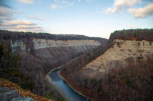
Centered around deep gorges and towering waterfalls, the landscape is quite hilly. However, many of the destinations in the park are accessible by car.
When we arrived, we were met with a mesmerizing deep gorge with the Genesee River lining the bottom and a bright orange sign reading, “Warning! Hunting Season in Progress.”
After looking at the views, we decided to try and go for a quick hike. Since we left rather late in the day, and did not arrive at the park until about 3:15 p.m., we did not want to go for a long hike and risk being trapped in the dark.
As we went up the steep hill, we could hear gunshots in the distance, no doubt from the hunters lurking around. After about 15 minutes or so, we decided to turn around and drive to what we came to see: the big waterfalls.
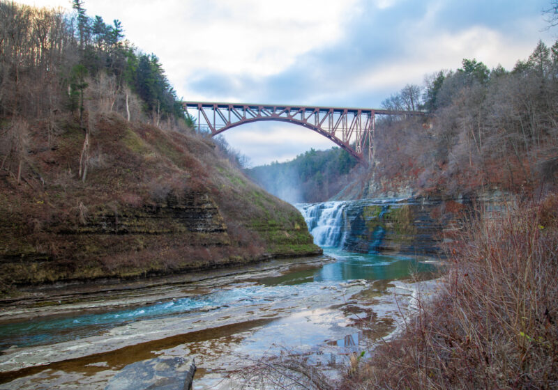
At Letchworth, there are three waterfalls. We visited the largest of them, the High Falls.
Towering over the waterfalls is an orange and brown railroad bridge, which, as we learned, had been home to many historic railways — including the famed “Erie-Lackawanna Railroad” between 1976-1999. Currently, however, the tracks are utilized by Norfolk Southern Railways and do not carry passenger service.
Without cell service, we relied on the signs to guide us the right way, and finally we arrived at a parking lot with picnic benches and a staircase. To get to the overlook point above the falls, we had to climb what seemed like a never-ending staircase to heaven, on which we would occasionally feel the cold mist go over us as we climbed.
This would no doubt be a refreshing relief in the summer, but less so in mid-November.
Along the way, however, were different photo spots where you could capture the perfect selfie.
What I also thought was interesting was that, as you climbed up, you followed the outline of the cliff and you can see how the type of rock changes as you gain altitude.
In the end, while the climb was interesting and good exercise, I still found the best view to be from the bottom by the picnic benches.
We learned later that you could also drive to the top; however, I feel that this would have robbed me of the sense of accomplishment I had when I reached the end of the staircase.
I should also warn any prospective travelers that during the off-season, the bathrooms are closed and locked, which is definitely something you should keep in the back of your mind when traveling.
After getting back down to the bottom, my favorite photo spot was the first of the overlooks and features a small terrace outcropping where you can stand to get the perfect image.
After getting our photos and being unhelpfully misled into thinking there would be a bathroom, we decided to go back to the car and do some exploring.
While the afternoon had definitely offered some picturesque landscapes, I like adventure, and so we decided to do some looking-around.
I had looked on the map back when we had cell-service and found that there were trails on the opposite side of the Genesee.
Based on memory, we navigated out of the park, through the downtown, and back into the park.
Near the other entrance to the park, we saw an advertisement for cabin lodging and so we decided to follow the dirt road to see where it would take us.
While not nearly as rattling as the Canadian adventure, this road still offered its fair share of bumps and puddles.
Now that it was getting dark, some of the passengers in the car became worried — however, I was very determined to see what was at the end of this long dirt road as we had already been driving for 15 minutes.
Soon, we saw what appeared to be a collection of small rustic cabins all located together on the side of the road. I decided to pull over and investigate these structures resembling a young child’s Lincoln Log creation.
Clearly the park caters to more guests during the peak summer season, as evident by the locked doors and the fact that no one seemed to be staying in any of the cabins.
Out of curiosity, I shined my flashlight to see if I could tell what the interior would look like.
Unfortunately, you could not see much: just the many carvings of people’s names on the wood exterior and what seemed to be stacked furniture inside.
Given what I saw, “cabin” may have been a generous term. It really was a small structure with four walls which did not seem much bigger than a dorm room. Since I could not enter the structure, I can not attest to whether this is true, but I do not think there was a bathroom inside.
Unless it is somehow like the police box from Dr. Who, there simply would not be any space to have such facilities — from what I saw.
Deciding we wanted to see more, we got back in the car and went further down the dirt road.
While the posted speed limit was 25 mph, going that fast would almost certainly end with popped tires and damage to your suspension. 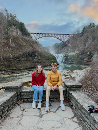
The road riddled with muddy potholes required expert maneuvering and slow speeds to avoid hurting my already tortured car.
The only other people we saw on the road were hunters with their pickups and Ford F150s — which no doubt had no difficulty navigating the rocky-road.
The road, which we later found out is named “Big Bend Trail” ranges in width from being wide enough to easily accommodate two-way traffic, to a narrow single lane road with a deep trench on either side. With the large pickup trucks frequenting the road, the question of “Who’s gonna back up?” when two cars needed to pass lingered in my mind.
Now dark outside, we were nearing the end of the trail. We climbed this steep, rocky, hill as my engine screamed, and we finally came over.
The trail climaxed with a beautiful view overlooking the valley below — which was definitely worth the drive.
We pulled off to the side to take in what we saw (with one of the passengers still irked from the experience deciding to wait in the car).
Since the night we visited was a full moon, we saw this bright orange halo hover just above the valley below. I think that this may have looked nicer had it been sunset, but I am still glad that we went to see it.
After we got back into the car, I decided that we had enough adventure for one day given that it was now pitch black and my car’s headlights were an oasis in a sea of darkness.
Since Teddy’s Travels serves as both a guide and a review, this is my breakdown for how I decide how many “Teddy Stars” to award a destination:
- Price: This was an easy, low-cost trip. Since it was the off-season, there was no one manning the toll booth at the park entrance, which, if I remember correctly, would have set you back about $10 per vehicle in the peak season. The only real cost of the trip was food and fuel. Since we were only there for a few hours, we didn’t really have any food other than a quick stop for fries at McDonalds on the way back. For fuel, Letchworth sits about 50 miles from the UR campus, and I would estimate that we drove an additional 15 miles inside the park. On our way there, we got gas for $3.39 per gallon which, given a MPG rate of 25.9, would bring the total fuel cost for the trip to $15.06 for a 115 mile trip.
- Food: As I said, since we were there only for a few hours, we really didn’t get to try any of the local restaurants. Being a state park, there was much emphasis on “bring your own food” rather than relying on a restaurant. That being said, the quaint downtown Portageville was not exactly barren. Also, during the peak season, there is a small snack-shop which is set up next to the waterfalls. There is also a small, which one of my passengers Lucy Rivers, described as a “spooky Glen Iris” inn situated next to the river, which also may serve food. According to the map, the very small town seems to have one restaurant “Letchworth Pines” situated off State Route 19A.
- Parking: Parking was no issue, especially during the off-season. The lots had plenty of space and we were even able to just leave the car doubled-parked (with the hazards on) on the side of the road to take a quick picture without a problem.
- Shops: There is a visitors’ center present near the entrance to the park which if you would like to get a map would recommend you visit, but for us it was not necessary.
- Adventure/Fun: As with all my trips, there definitely was adventure. I personally liked the quiet hike we went on and also climbing up the stairs to the top of the cliff near the waterfall. Had we left earlier in the day, I would probably have gone on a longer hike, which I would highly recommend to anyone visiting. I would suggest downloading the map to your phone ahead of time due to the spotty cell service. The best spots I would recommend is taking a look at the Glen Iris Inn located on Park Road and checking out the waterfalls as well as the large gorge near the visitors’ center.
Given my experience, and that it was also not the peak season, I would give this trip 3½ out of 5 Teddy Stars. However, I think that this definitely has potential and would recommend anyone to go, but during a different time of year.
